Curve Advisory Speed Analysis Using Mobile LiDAR
Sincere thanks to our friends at the Florida Engineering Society for publishing our latest article in the May 2019 issue of their Journal!
 According to the U.S. Department of Transportation Federal Highway Administration, public agencies have invested $1.75 trillion in transportation assets. Over the past decade, Transportation agencies have experienced an increased need for a better means of inventorying asset condition due to high risk failures. The calculation of the safe speed by which to travel around roadway curves is one such asset. And time is ticking to complete the reevaluation of these designated speeds and corresponding signage.
Deadline Looming
The 2009 MUTCD (Manual on Uniform Traffic Control Devices) presented explicit requirements for signing curves and gave us a 10-year grace period to get this job done. Well, time is almost up, because that compliance deadline is December 31, 2019! And if you’re not in compliance you will be in violation of a federal code.
History
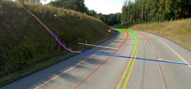
For many years, the evaluation of the safe travel speed for highway curves has been a subjective practice. Based on the curvature geometry and superelevation, this safe speed limit historically has been determined using conventional, boots-on the ground survey methods. In many states, the reliance on “ball bank” tools and hand measurements in the field has made this a somewhat inefficient and inexact science. For instance, the Ball Bank Indicator method requires multiple speed test runs for each curve in both directions in 5 MPH speed increments. According to a white paper approved by the Transportation Research Board (TRB) entitled The Effective Use of Mobile LiDAR Data for Curve Advisory Speed Analysis, (2017) by Patel, DiGiacobbe, Knaak, Kharva:

“This approach typically encounters inconsistencies in advisory speeds due to variation in test vehicles classification, equipment calibration, steering corrections (driving style) and ability to maintain constant speed while traversing the entire curve. It may also require an additional person to document the results and, more often, conservative speeds are being posted which results in increased non-compliance by drivers.” This method takes time and even slight inaccuracies can lead to potential danger to the traveling public if “reduced speed” signs may be posted with higher speeds than what is actually advisable.
Click here to read on to see how utilizing mobile LiDAR is quickly becoming the tool of choice for analyzing highway curves to determine the advisory speed more accurately while increasing safety and reducing time spent in the field.