Surveying Florida’s Integrated Highway Solution
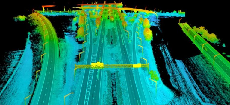
“From Disney World to game day for the NBA’s Magic, Orlando’s 2.5 million-person metro area is generating growing demand for increased roadway capacity. But any surveying that involved closing Central Florida Expressway SR417-149 to widen it would pose major driving issues. Similarly, working with LiDAR would need to negotiate traffic flow and safety, as well as restrictions on UAS flights.”

Read all about it in the May Issue of Inside Unmanned Systems by Abe Peck, Executive Editor of Inside Unmanned Systems magazine or sit back and watch the video! See how Maser Consulting’s geospatial survey team created the perfect storm by leveraging the use of mobile, aerial and terrestrial LiDAR to integrate data for high-accuracy, 3D deliverables for a Central Florida Expressway lane widening project in a safe and cost effective way!
And if you like that, check out Inside Unmanned Systems’ Webinar Recap “Taking Advantage of all That UAS LiDAR has to Offer.” Rob Dannenberg, UAS Discipline Leader for Maser Consulting, joins Moderator General James Poss, Maj Gen (retired) and CEO of ISR Ideas; My-Linh Truong, ULS/UAS Segment Manager at Riegl USA, and Russ Faux, Sr.VP for Strategic Initiatives, Quantum Spatial, Inc. To watch the full webinar, click GOTOWEBINAR.